All about maps: from a mammoth tusk to a mobile app
You’ll always use a map if you need to get to a new place: whether in your hometown or another continent. So let’s take a look at how people made and used maps.
From the symbolic representation to navigation
What is the best way to give your friend directions? Just drop a pin on their favorite map app. Some twenty years ago, you might have grabbed a pen to draw a simple map on a napkin.
The desire to map the space around us seems to have been deeply rooted in our daily lives since the dawn of time. In fact, our ancestors made their first maps dozens of thousands of years ago.

The history of cartography begins as early as the Late Stone Age. We have found various objects the early humans might have used as maps (it is hard to know for sure after that many years—and it’s not like the users are here to tell us the story). Examples include engraved mammoth tusks from archeological sites of Pavlovo (Czechia) and Mezhyrich (Ukraine), cave paintings in Lascaux (France), murals at the largest proto-city settlement of Çatal Höyük (Turkey), and a polished stone tablet from Navarre (Spain).
Aboriginal people living near the Darling River (Australia) used cylindrical stones marked by incisions: they are considered the earliest means to pass around recorded messages. Some of the stones might contain maps.
Several thousand years later, in the Bronze Age, the first civilizations made significant progress exploring the world. Trading and sailing gave people a bigger perspective of the world and brought a need for navigation.
Ancient Mesopotamian cultures take us closer to modern mapmaking. Babylonian clay tablets from the third millennium BCE show schematic drawings of cities, rivers, valleys, and hills. They also include scripts naming a location and marking four directions—North, South, East, and West.
At this time, a map expressed people’s want to understand their place in the world. Most of the earliest maps are made with this in mind, including the first known map of the world, Imago Mundi.

This clay tablet, created in 600 BCE, places Babylon in the center of the world, surrounded by the “Bitter River.” It also mentions geographical regions the mapmakers knew about, as well as certain mythical places. However, this map was not a geographical model but rather a symbolic one. Its purpose was to explain the mythological world.
As science developed, people applied their newfound knowledge to make maps. For instance, Ancient Greeks used their advances in mathematics, astronomy, and geography for mapmaking. They were, probably, the first people to prove the spherical shape of the Earth and measure its circumference.
The Roman Republic (which later became the Empire) had constantly conquered new lands. Its continued expansion created a steady demand for maps of newly acquired territories. Cartography came to serve political needs, becoming a crucial tool for waging military campaigns and imposing taxation.
The Tang dynasty unified China in the 7th century CE and ruled for three centuries: this period is now considered a golden age of Ancient China. During that time, the emperor obliged every province to submit the map of their territory every three years. From that, the imperial officials created maps of the entire country.
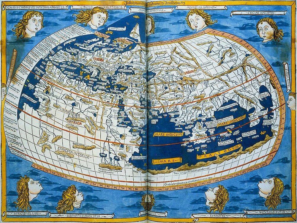
Back in Europe, some significant works of ancient scholars were lost and forgotten for centuries. For example, Ptolemy’s Geography, written in the 2nd century CE, was rediscovered only in the late 13th century and translated into Latin in 1406. In the meantime, geography and cartography had taken a slightly different direction under the influence of the Christian church.

Maps of the European Middle Ages (also called Mappa Mundi) were primarily conceptual depictions of the world divided into three parts (usually with the holy city of Jerusalem in the center): Europe, Asia, and Africa. A conventional theory among scientists and kings was that one would arrive in China by sailing West from Europe. Kings were looking for new riches and trade routes that would bypass the Ottoman Empire, which by that time grew stronger and assumed control over the old Eastern passages. As a result, they supported seafaring, trade, and cartography, eventually funding the expeditions that would discover the Americas for Europeans.
Before contact with Europeans in the 16th century, native tribes and civilizations of the American continents had their own cartographic tradition. Olmecs, Mayas, Zapotecs, Teotihuacan, Mixtecs, and Aztecs used surveys and made detailed maps of their lands. In addition to depicting the geographical space, pre-conquest Mesoamerican maps could show changes over time, serving as a crucial storytelling tool.

The discoveries triggered the European “Age of Exploration,” when cartography thrived as one of the most important sciences for a while. The following centuries of global conquest, trading, and colonization brought about many dramatic changes to the world. Many peoples were eradicated or had their ways of life irreparably damaged. However, the new reality created a new, connected understanding of the world. The demand for cartography grew, especially as European powers vied for control over their colonial possessions.

The Industrial Revolution introduced further changes: as new cities, roads, and railways appeared, people needed even more maps. Finally, the rapid growth of technological and scientific progress allowed us to draw the most precise maps in history.
However, the main reasons to create a map have remained the same since the dawn of cartography. Like millennia ago, we still are eager to explore and travel the world. And maps seem to be the best helpers in these endeavors.
The revolutionary maps you should know about
Perhaps, the first well-known ancient cartographer was the Greek philosopher Anaximander (610–546 BCE). Anaximander’s map introduced the concept of a cylindrical world, divided into three parts and surrounded by water.

Do you recognize the shape? Nearly two thousand years later, medieval cartographers used the same concept in their Mappa Mundi. Although Anaximander’s world map did not survive, it had significantly influenced further generations of European cartographers, who used his work mainly for political, economic, and philosophical purposes.